What is rural? What is Urban?
These questions have plagued this semester for me, not only in this class on rural geography but also in my contemporary geographic thought class where Sofia and my seminar topic was changing rural geographies. Also my Applied Geomatics project has been on the subject of siting urban agriculture in Hamilton, as I will discuss later this has brought up the same questions regarding the rural-urban binary.
In class last Thursday, idea that the physical distinction between urban and rural as determined by municipal boundaries can have very real effects on landscapes and society. Someone brought up the problem of differing infrastructure qualities between these two regions. Another person brought up how this can have effects on which schools people attend and even the perspective that society has on members who live across imaginary lines.
I found it fascinating that although these lines seem so arbitrary and the distinction between urban and rural so hard to define, they have very real effects on the lay of the land and the people who live on one side or another of those lines.
So how does this relate to my Geomatics project of siting an urban Farm in Hamilton?
Well first let me give you some back ground on my project. Me and my partner Amilah Rasool developed a GIS based model to determine the best sites for urban agriculture in Hamilton. The model incorporated a variety of criteria (slope, aspect, soil type, hydrological sensitivity and income) to create a suitability analysis for urban farming. Then vacant properties in urban Hamilton (as defined by the municipality) were ranked then to determine which were the most suitable. The following maps show the two properties (A&B) which were chosen as the ideal locations for urban agriculture.
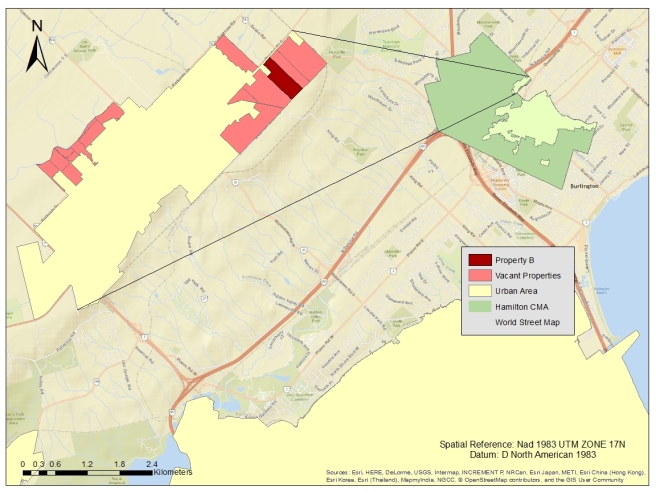
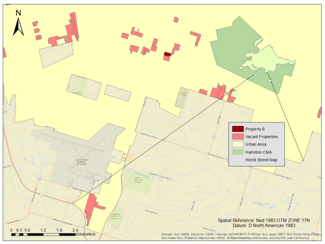
The inset map shows the location of these properties within the Hamilton Census Metropolitan Area (CMA). Anything outside the yellow urban area is considered rural but still apart of the Hamilton CMA. Both Property A and Property B are very close to the boundary which divides rural and urban. This binary distinction between rural and urban has created a limitation within my GIS model. Areas just outside of the urban area that still could have serviced urban residents are excluded from the analysis. Moreover areas that are distinctly rural but have been classified as urban for development purposes are being considered for urban agriculture. This is the case for Property A, which technically falls within the urban enclave of Waterdown but by most classifications would be rural. There are no nearby bus stops, most of the land is open fields and it is surrounded by agriculture. If this property became a farm it would be hard to classify it as an urban farm since it is not really in an urban area.
This certainly points to some of the flaws of my GIS project, which probably should have included population and public transportation as criteria, but it also brings up how the arbitrary rural urban divides have real world effects.